This shapefile was obtained from the Alaska Division of Elections and processed by members of the Metric Geometry and Gerrymandering Group (MGGG).
The precinct shapefile and election results were downloaded from the Alaska Division of Elections website. Demographic data was downloaded from the 2010 Decennial Census at the census block level from IPUMS NHGIS.
Election data from the Alaska Division of Elections was cleaned and converted to a CSV by MGGG staff so it could be joined to the precinct shapefile. Demographic data was aggregated from the block level to the precinct level using MGGG’s proration and roundoff tools. Roundoff was used to assign Alaska house districts to precincts.
ID: Unique identifierAREA: Area of precinctDISTRICT: Precinct codeNAME: Precinct name and codePOPULATION: Total population in precinctUSH14D: Number of votes for 2014 Democratic house candidateUSH14R: Number of votes for 2014 Republican house candidateUSH14L: Number of votes for 2014 Libertarian house candidatePRES16D: Number of votes for 2016 Democratic presidential candidatePRES16R: Number of votes for 2016 Republican presidential candidatePRES16L: Number of votes for 2016 Libertarian presidential candidatePRES16G: Number of votes for 2016 Green Party presidential candidatePRES16C: Number of votes for 2016 Constitution Party presidential candidateSEN16D: Number of votes for 2016 Democratic senate candidateSEN16R: Number of votes for 2016 Republican senate candidateSEN16L: Number of votes for 2016 Libertarian senate candidateUSH16D: Number of votes for 2016 Democratic house candidateUSH16R: Number of votes for 2016 Republican house candidateUSH16L: Number of votes for 2016 Libertarian house candidateGOV18D: Number of votes for 2018 Democratic gubernatorial candidateGOV18R: Number of votes for 2018 Republican gubernatorial candidateGOV18L: Number of votes for 2018 Libertarian gubernatorial candidateUSH18D: Number of votes for 2018 Democratic house candidateUSH18R: Number of votes for 2018 Republican house candidateTOTPOP: Total populationWHITE: White populationBLACK: Black populationAMIN: American Indian and Alaska Native populationASIAN: Asian populationNHPI: Native Hawaiian and Pacific Islander population2MORE: Two or more races populationVAP: Total voting age populationWVAP: White voting age populationBVAP: Black voting age populationAMINVAP: American Indian and Alaska Native voting age populationASIANVAP: Asian voting age populationNHPIVAP: Native Hawaiian and Pacific Islander voting age populationOTHVAP: Other race voting age population2MOREVAP: Two or more voting age populationHDIST: AK house district
This shapefile uses a NAD83/Alaska Albers projection or EPSG: 3338.
We give this shapefile an A rating. All data was obtained from the state government and was processed by MGGG staff.
The three dual graphs in this repository have been created via the process outlined in an MGGG examination of Alaska's nested districts, available as a preprint here. Though we recommend consulting the paper for a deeper understanding of the dual graph constructions, the following principles were used :
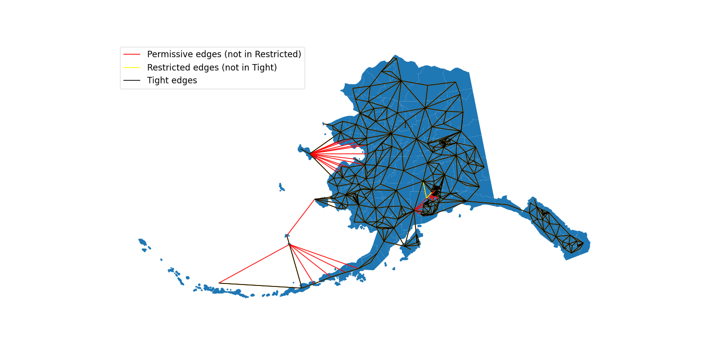
ak_permissive.json: this graph represents the permissive graph from the paper, in which precincts are considered connected even if they only touch via a water border. The only manually fixed discontinuity were in the Kodiak Islands and in island precincts along the coast of western Alaska.ak_restricted.json: this graph represents the restricted graph from the paper, in which precincts were first clipped to land using the Census Bureau Cartographic Boundary file, which removes some edges that cross waterak_tight.json: this graph represents the tight graph from the paper, and keeps the fewest number of water adjacencies in place possible to consider the current State House map fully connected.
All three graphs are fully connected, and the edges in tight are a subset of those in restricted, which is in turn a subset of permissive. A comparison of the edges can be seen in the following image:

If planning to run GerryChain on this shapefile, we suggest loading one of these graphs via Graph.load_json() instead of creating a graph from Graph.from_file() and saving that graph locally for further use.