A Global Inventory of Commerical-, Industrial-, and Utility-Scale Photovoltaic Solar Generating Units
Repository for machine learning and remote sensing pipeline described in Kruitwagen, L., Story, K., Friedrich, J., Byers, L., Skillman, S., & Hepburn, C. (2021) A global inventory of photovoltaic solar energy generating units, Nature 598, 604–610.
Photovoltaic (PV) solar energy generating capacity has grown by 41% per year since 2009. This rapid deployment of solar energy must continue if climate and Sustainable Development Goals are to be met. Energy system projections that mitigate climate change and facilitate universal energy access show a nearly ten-fold increase in PV solar energy generating capacity by 2040. Geospatial data describing the energy system is required to manage generation intermittency, mitigate climate change risks, and identify trade-offs with biodiversity, conservation, and land protection priorities caused by the land use and land cover change necessary for PV deployment. Currently available inventories of solar generating capacity cannot fully address these needs. Here, we provide a global inventory of commercial-, industrial-, and utility-scale PV solar energy generation stations (i.e. PV generating stations in excess of 10kW nameplate capacity) using a longitudinal corpus of remote sensing imagery, machine learning, and a large cloud computation infrastructure. We locate and verify 68,661 facilities, an increase of 253% (in number of facilities) on the previously best-available asset-level data. With the help of a hand-labelled test set, we estimate global installed generating capacity to be 423GW [-75GW, +77GW] at the end of 2018. Enrichment of our dataset with estimates of facility installation date, historic land cover classification, and proximity to protected areas and indigenous and community lands allows us to show that the majority of the PV solar energy facilities are sited on cropland, followed by aridlands and grassland. Our inventory can aid PV delivery aligned with the Sustainable Development Goals.
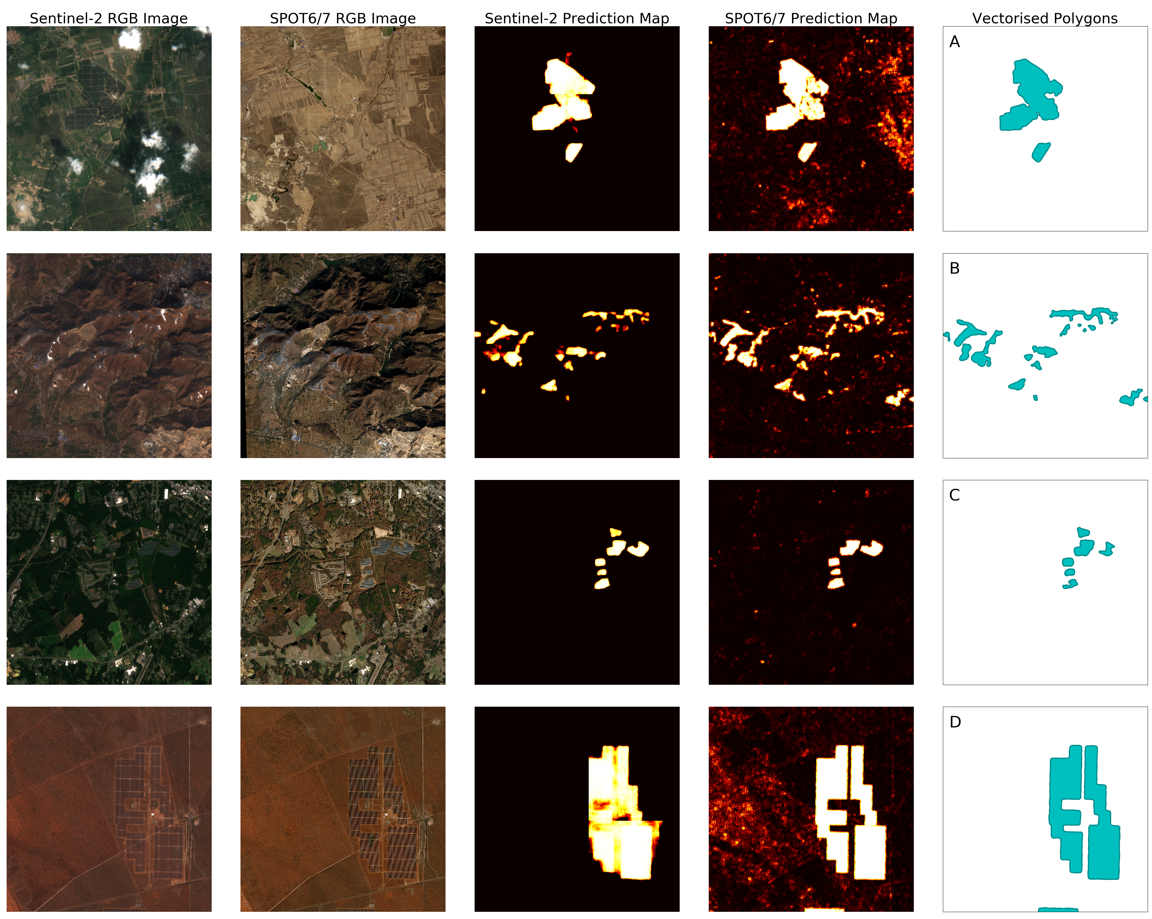
Figure 1: We detect utility-scale (>10kW) solar PV facilities with machine learning in Sentinel-2 and SPOT6/7 remote sensing imagery. Here, we show out-of-training-sample examples showing SPOT6/7 and Sentinel-2 optical imagery, primary inference from U-Net2 computer vision models, and vectorised polygon outputs. Our models are robust to a variety of geometries and orientations, land covers, seasons, and atmospheric conditions.
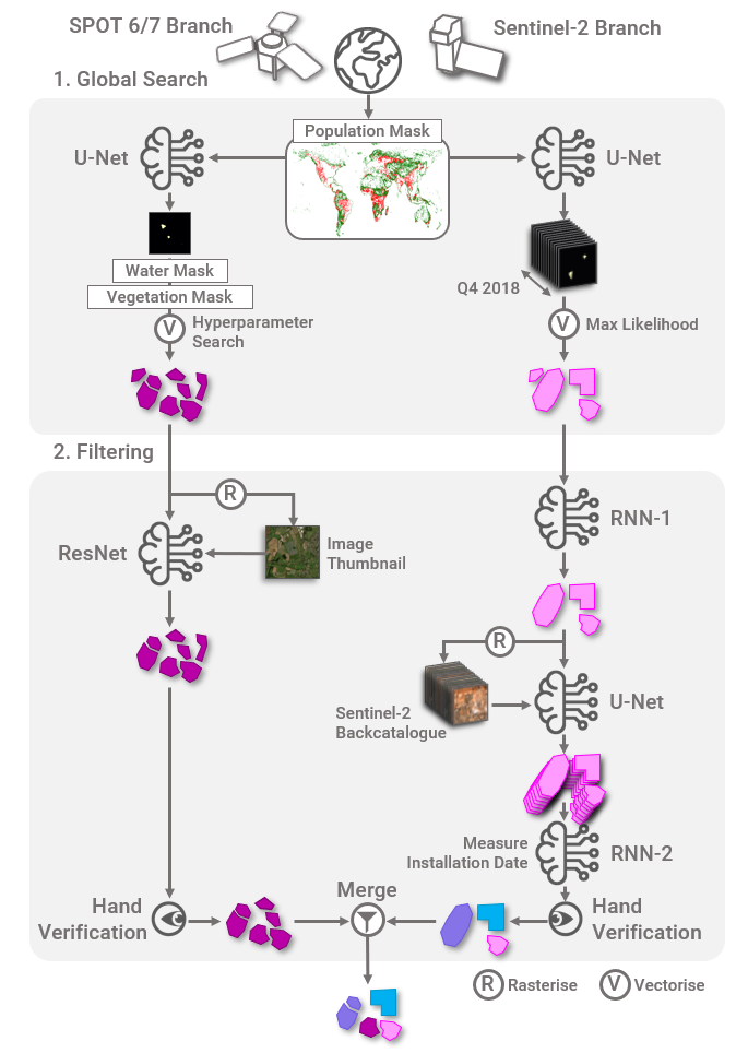
Figure A1: Our machine learning pipeline diagram. The pipeline was split into two branches, one for each satellite constellation, and two steps: global search to minimise false negatives, and filtering to eliminate false positives. The pipeline was deployed on 72.1mn km2, approximately half of the Earth's land surface area, based on population density. Additional machine learning models were used to filter the dataset for false positives. The remaining detections were verified by hand to ensure a high-quality dataset. Installation date for each solar PV facility was inferred heuristically from the detection timeseries.
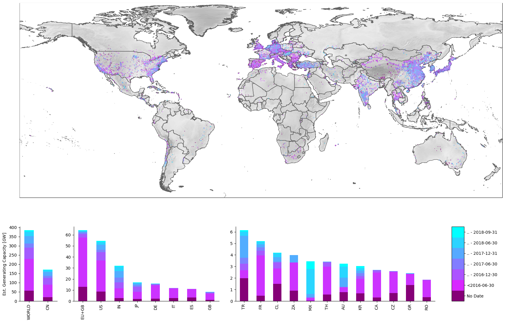
Figure 2: We deploy our pipeline on imagery captured until 2018-12-31, providing a snapshot of the state of utility-scale solar PV diffusion at the end of 2018. We visualise our dataset and observe the emegence of hotspots in space and time. We use global data for incident irradiation and solar PV productivity to estimate facility-level AC generation capacity. Over our 30-month study window, we observe an increase of 81% in deployed generating capacity, led by increases in China (120%), India (184%), the EU-27+GB (20%), the United States (58%), and Japan (119%).
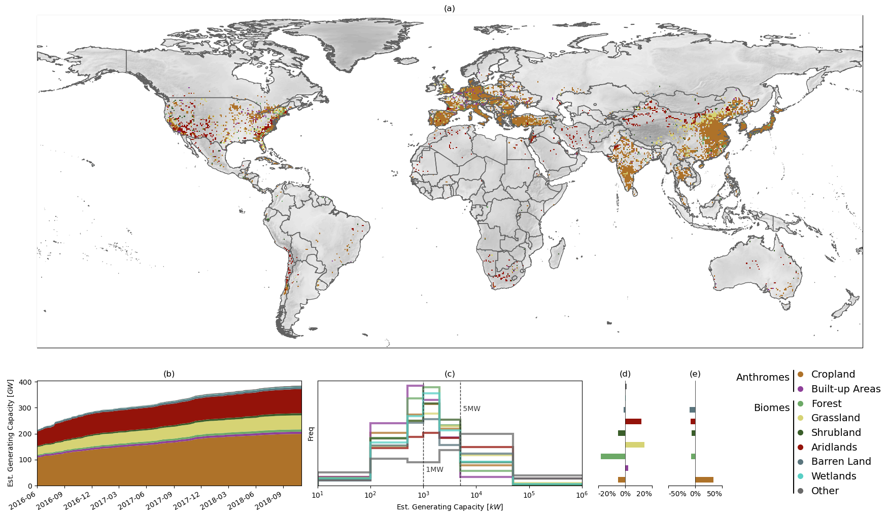
Figure 3: To demonstrate the utility of our asset-level dataset, we prepare an analysis of pre-installation landcover for utility-scale solar PV. The land chosen for the development of solar PV has impacts on and trade-offs with the costs of the solar PV system, greenhouse gas emissions net of land cover change, ecosystem health, water resources and good production, land and property values, and political acceptability, and so is an urgent priority for study. We find no consistent trend in land cover chosen for solar PV development over the study period (panel b), and we observe that the areas chosen for PV deployment skew heavily towards areas with excessive cropland (panel e). However, within these areas, deployment skews to barren and grasslands (panel d). Installation size skews larger for barren land covers (i.e. solar PV mega-projects) and smaller for developed areas (i.e. rooftop commercial and industrial installations)(panel c).
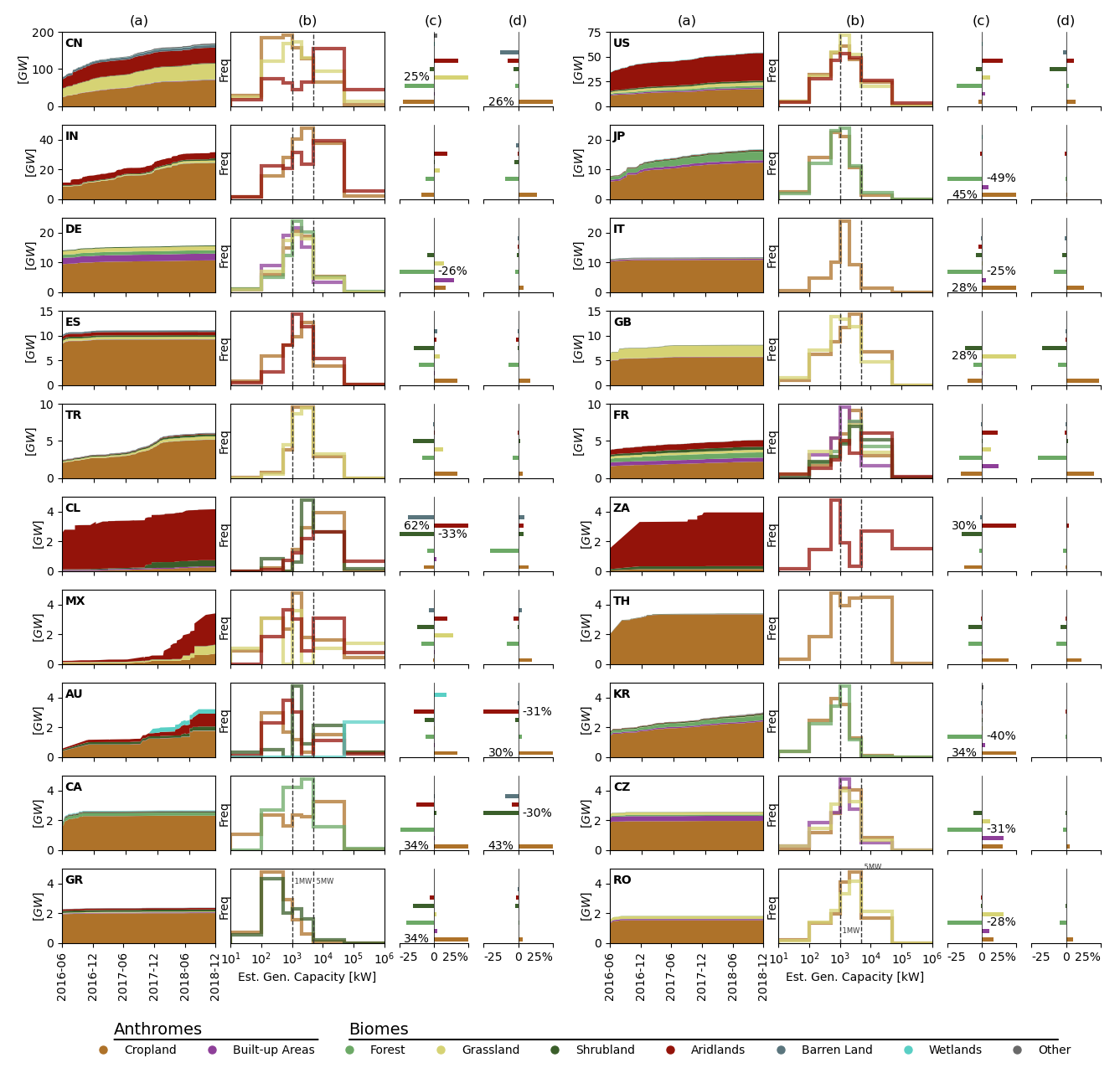
Figure A10: We provide analysis at the country-level for the top 20 countries in our dataset. PV installations in most countries displace cropland. China, Chile, India, and South Africa have barren-land PV megaprojects. Among European Economic Area countries, France and Germany are unique for showing a local skew towards developed areas, while all others show a reinforced skew towards croplands. Development in most countries appears to disfavour sites with pre-existing forests, with the exception of South Africa.
Recognising the fundamental public-goods nature of asset-level data and its importance in the urgent mitigation of climate change, we make our dataset publicly available.
The complete dataset can be downloaded from the Zenodo data repository.
An interactive visualisation of our dataset is from the World Resources Institute here.
The authors acknowledge the generous contribution of Descartes Labs, Inc. which provided the authors with API credentials for easy imagery access and manipulation, and a cloud computation platform for imagery analysis. Descartes Labs is spin-out company from Los Alamos National Laboratory that provides a data refinery for satellite imagery. The authors also acknowledge the generous support of the World Resource Institute who provided insight and data resources to the project. Wiki-Solar also provided valuable insight and data. The Sentinel-2 semantic segmentation model was trained on Amazon Web Services with a supporting grant. The hand-verification of Sentinel-2 detections was supported by Microsoft Azure cloud computing services with credits provided by the AIforEarth program.
We recommend using Conda for package and environment management. Create a new conda environment:
conda create -n solar-pv python=3.6
Clone this repository using git:
git clone
Add the directory root to the Python path environment variable:
export PYTHONPATH=$(pwd):$PYTHONPATH
(optional) You may want to add this to a bash script for your environment:
touch //path/to/conda/envs/solar-pv/etc/conda/activate.d/env_vars.sh
nano //path/to/conda/envs/solar-pv/etc/conda/activate.d/env_vars.sh
Then input:
export PYTHONPATH=$(pwd):$PYTHONPATH
and save and exit.
Install Python packages via pip:
pip install -r requirements.txt
Descartes Lab alpha and Airbus SPOT6/7 access is required to run this repository.
Matching installations to existing data uses a mixed integer linear program specified using PuLP. We use Gurobi, a commercial solver, to solve the linear program. Gurobi requires a license, it can be installed with:
conda config --add channels http://conda.anaconda.org/gurobi
conda install gurobi
- solarpv\
- training\
- s2\
model_resunet.json: ResUNet specificationS2_training_data.py: Training data generator from cloud resource to disktraining_data_mp.py: Multithreaded training data generator from cloud resource to disktrain_S2_RNN1.py: Training for S2 Branch RNN-1train_S2_RNN1.py: Training for S2 Branch RNN-2train_S2_unet.py: Training for S2 Branch UNet with generator from dist
- spot\
generator.py: SPOT UNet training generatoroptimizer.py: SPOT UNet training optimizertrain.py: SPOT UNet training entry pointtrain_classifier.py: SPOT classifier training entry pointtrain_solar_unet.ipynb: SPOT UNet training prototypingtransforms.py: SPOT UNet training transformsunet.py: SPOT UNet model generator
- s2\
- deployment\
cloud_dl_functions.py: Pipeline functions for deployment on DL tasks queuingcreate_cloud_functions.py: Scripts for deploying DL cloud functionscreate_cloud_products.py: Scripts for creating DL cloud products for reading/writing by cloud functionspipeline.py: Entrypoint for running geographies through the deployment pipelinestore_model.py: Scripts to push inference models to cloud storage
- analysis\
- quality\
deploy_precisions.ipynb: Notebook for obtaining precision of S2 and SPOT branch deploymentprecision-recall.ipynb: Notebook for obtaining cross-validation precision, recall, and intersection-over-union for all pipeline stagesS2_band_dropout.py: Band dropout analysis for the primary S2 inference modelSPOT_band_dropout.ipynb: Band dropout analysis for the primary SPOT inference model
- matching\
match_region.py: Mixed-integer linear programming (MILP) matching script for our dataset with other asset-level datamatch_postprocess.ipynb: Notebook to extract insight after matching between our dataset and other available datasetsMILP_WRI-matching_stripped.ipynb: Prototyping for MILP matchingvincenty.py: Vincenty geodescic distance scripts
- landcover\
add_land_cover.py: Multithreaded script for adding land cover to PV detectionscloud_land_cover.ipynb: Notebook for cloud-based addition of land cover to PV detectionsland_cover_skew_analysis.ipynb: Notebook for analysis of land cover in our PV detectionsland_cover_skew_deploy.ipynb: Notebook for cloud-based reduction of land cover across large geographies
- generating_capacity\
MW_capacity.ipynb: Add generating capacity to PV detections
- quality\
utils.py: Shared utilities
- training\
- makefigs\
fig-1_prediction_map.py: Script to generate Figure 1fig-2_results_map.py: Script to generate Figure 2fig-3_fig-A10_maplandcover.py: Script to generate Figure 3 and Figure A10fig-A2_area_dist.py: Script to generate Figure A2fig-A3_deployment_area.py: Script to generate Figure A3fig-A6_PR_summary.py: Script to generate Figure A6fig-A7_deploy_precision.py: Script to generate Figure A7fig-A8_band_perturbation.py: Script to generate Figure A8fig-A9_install_date_US.py: Script to generate Figure A9- figures\
- [All figures used in the preparation of the paper]
- data\
- [All data used in the training, deployment, and analysis workflows]
- bin\
CORINE2DL.ipynb: Notebook for uploading Copernicus CORINE land cover products to DL productgenyaml_cloudfunctions.py: Script to generate DL cloud function YAMLgenyaml_cloudproducts.py: Script to generate DL cloud product YAMLmake_S2_cv_samples.py: Script to generate samples for S2 Branch cross-validationMODIS2DL.ipynb: Notebook for uploading MODIS land cover products to DL productcolor_gdf.ipynb: Notebook to add color to PV detections for Earth Engine visualisation
All data, including training, validation, test, and predicted datasets, is available to download from the Zenodo repository. An interactive visualisation is also offered by the World Resources Institute ResourceWatch.
- Sentinel-2 training samples can be generated using the multithreaded generator:
python solarpv/training/s2/training_data_mp.py- Train the primary inference UNet model, RNN-1, and RNN-2
python solarpv/training/s2/train_S2_unet.py
python solarpv/training/s2/train_S2_RNN1.py
python solarpv/training/s2/train_S2_RNN2.py- SPOT training samples use proprietary Airbus SPOT6/7 imagery and so must be retained on an infrastructure licensed for SPOT6/7 imagery. Training the SPOT branch requires access to the DescartesLabs platform. Contact the authors for details.
- Obtain the UNet training imagery and move these images into
data/SPOT_train/ground/and obtain or developtrain_keys.txtandval_keys.txt. - Train the SPOT UNet model, entering the SPOT training scripts with
solarpv/training/spot/train.py:
python solarpv/training/spot/train.py --train- Obtain the classifier training imagery and move these images into
data/SPOT_train/classifier_ground/and sort them intotrainandval, andnegandposwithin each. - Train the SPOT classifier model:
python solarpv/training/spot/train_classifier.py --train- Deployment makes use of the DescartesLabs platform. DescartesLabs alpha access is required to successfully deploy the machine learning model. Contact the authors for details.
- Generate the YAML which tracks the cloud functions and cloud products used in the pipeline deployment.
python bin/genyaml_cloudfunctions.py
python bin/genyaml_cloudproducts.py- Generate the cloud product and the cloud functions.
python solarpv/deployment/create_cloud_products.py
python soalrpv/deployment/create_cloud_functions.py- Store the machine learning models
python solarpv/deployment/store_model.py --model_path="./s2_rnn1.h5"
python solarpv/deployment/store_model.py --model_path="./s2_rnn2.h5"
python solarpv/deployment/store_model.py --model_path="./s2_unet.h5"
python solarpv/deployment/store_model.py --model_path="./solar_pv_airbus_spot_rgbn_v5.h5"- Deploy geographies deploy pipeline stages to selected geographies. Pipeline stages must be one of
[S2Infer1, S2RNN1, S2Infer2, SPOTVectoriser], geographies must be an iso-3166-1 two-letter code. For example, to deploy the primary inference stage for the United Kingdom:
python solarpv/deployment/pipeline.py --model_path="S2Infer1" --geography="GB"- Run the cross-validation precision-recall notebook
solarpv/analysis/quality/precision-recall.ipynb - Run the deployment precision nodebook
solarpv/analysis/quality/deploy_precision.ipynb - Run the S2 band dropout script
solarpv/analysis/quality/S2_band_dropout.py - Run the SPOT band dropout
solarpv/analysis/quality/SPOT_band_dropout.ipynb
- Run the generation capacity notebook
solarpv/analysis/generating_capacity/MW_capacity.ipynb
- Run the cloud land cover notebook
solarpv/analysis/landcover/cloud_land_cover.ipynb - Run the cloud land cover skew notebook
solarpv/analysis/landcover/land_cover_skew_deploy.ipynb - Run the land cover skew analysis notebook
solarpv/analysis/landcover/land_cover_skew_analysis.ipynb
- Match geographies of interest with the WRI Global Power Plant Database and the EIA power plant dataset using
solarpv/analysis/matching/match_region.py:
python solarpv/analysis/matching/match_region.py --dataset="wri" --geography="GB"- Postprocess the matches with
solarpv/analysis/matching/match_postprocess.ipynb
