A small demo project for recruitment.
Requirement is to make geofence alert feature that notifies the user whenever he/she enters and exits a specified region and using Google Location API is not allowed.
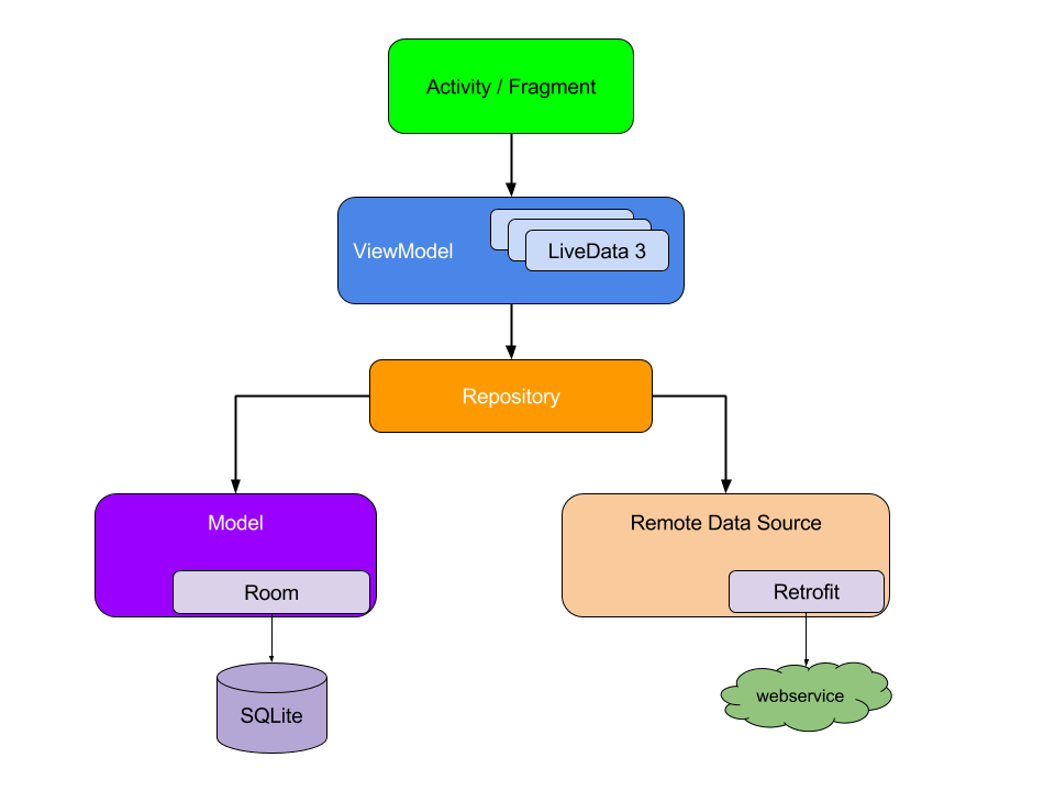
Project utilises the official Jetpack (former Architecture Components) components to implement recommended clean app architecture which is robust, maintainable and easy to test. A ViewModel is created to encapsulate UI-related data in a lifecycle aware way, to make app architecture more flexible and easy test data handling is not integrated into activity nor viewmodel, a repository created as a single data source and it can be further implement multiple data sources local and remote. As a result activity and fragment only contained action related code and UI and data layer separated clearly.
Project consists of 5 main packages :
- data (include repository class which represents data layer.)
- db (include Room database class, dao and a helper class.)
- model (include a model classes that key part of the application.)
- service (include a service classes that handles geofence trigger.)
- ui (includes all ui related classes activities, fragments, other UI-related stuff.)
MainActivity
is the starting point of the app, that includes LocationChooserFragment
which is main UI component, LocationChooserFragment is literally a map that shows user created geofences, state of the
geofences indicated by different colors. There are two main user action in the fragment
LocationChooserFragment#addGeofence and LocationChooserFragment#RemoveGeofence, actions invokes from
fragment handled by repository through viewmodel, every time user invokes an action associated geofence
created or removed by LocationManger#addProximityAlert API and also saved to database for persistence.
At first my design scheme is to maintain a list of areas with minimum radius of 200 meters
and check them with 5 minutes latency using WorkManager. But implementing, testing and running correctly
seemed hard to accomplish in two days. After reading the LocationManager document I realize it has
offered addProximityAlert method to create geofence alert, so I achieve this scenario
using LocationManger#addProximityAlert API. Latency of the API is 5s to 10m and system uses it's
location service to optimize battery life and I checked the running services of the os in Xiaomi 10
it uses in-house FusionLocationProvider(which utilizes all kind of location providers) to fix location.
For showing the geofence on the map I use AutoNavi at first, they are map provider of the Apple in China and very popular here(also acquired by Alibaba). They also have FusionLocationProvider for optimization and provide location SDK that supports geofence. But after implementation I realize they don't have map data for many European countries, so I have no choice to use Mapbox Map and it took my day to familiar with it(especially drawing a circle):).
App is tested on 5 virtual device with API levels from 22 to 28, latency is in seconds if the app is in the foreground and 5min to 10min while in the background. This result is almost same when I test with physical device (XiaoMi Android Version 8.0).
To build and run project correctly you should fulfill some requirements:
Android Studio Version: At least 3.1
Gradle Version: 4.6
Android Gradle Plugin Version: 3.1.4
Build Tools: At least 28.0.0
Compile SDK Version: 28
Target SDK Version: 28
Minimum SDK Version: 22
Author: Alimjan Qadir
Email: [email protected]


